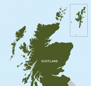
Out of the box – new mapping law comes into force
Shetland can no longer be put in a box – as of today.

Sections of the new Islands (Scotland) Act come into force, after being granted Royal Assent on 6th July.
Among the provisions are a Shetland mapping requirement, which means the isles must be accurately represented on official maps – and no longer included “in a box”.
It also provides for changes to the electoral representation of island communities – with greater flexibility around councillor representation of island communities to allow for one or two member wards.
Isles MSP Tavish Scott said: “There is no excuse now for the Scottish government, its agencies or others to put Shetland in a box. The box is closed.
“It doesn’t exist, whether that be in the Moray Firth or east of Orkney. Shetland is now in the right place. It is ridiculous that I had to change the law to make this happen but so be it.
“This Islands Act must go a whole lot further. Islands proofing – ensuring the islands are recognised in any law or government regulation – must work.
“There are too many cases right now where that is not happening, such as the government imposing car parking charges on lifeline airports where there is no public transport alternative.
“For the Islands Act to be worth the parchment it’s written on, these things must change.”
Islands Minister Paul Wheelhouse said: “The Scottish Islands have contributed and continue to contribute hugely to our culture and heritage and, with this Act now starting to take force, will now have the opportunity to contribute even further to their own and our collective futures.
“They have very distinctive needs so the Act introduces a number of measures to ensure there is a sustained focus across government and the wider public sector to meet the needs of island communities now and in the future.
“On a more visual front, it ensures Shetland will no longer be ‘boxed off’ on maps which has been a cause of irritation to those living in Shetland.
“When producing a map of Scotland, the Shetland Islands must therefore be displayed in a way that accurately and proportionately represents their geographical location in relation to the rest of Scotland.
“It introduces a new duty on Scottish ministers and the wider public sector to have regard to island communities when exercising their functions and preparing policy, strategies, services and legislation – known as “island-proofing”.
“And the National Islands Plan will also be produced which, amongst other things, gives us a strategic direction to improve outcomes for our islands by creating the right environment for investment, empowerment and increasing sustainable economic growth.”


Ronald Young
I’m glad to hear that Shetland (and Orkney?) can’t be put into a box on maps. It’s a start to getting the northern isles properly represented in their correct position on an atlas.
On a similar line, in a number of the paper atlases of UK that I have, the northern (end western) isles are represented at a completely different scale. In an old OS map book, the south (UK mainland) is shown at 3mile to the inch whilst the Northern isles are shown at about 7 miles to the inch. Similarly, a road atlas produced by RAC has The South shown at 4 miles to the inch whilst the northern isles can only get about 5.5 miles to the inch.
So, the next step should be to get the northern islands correctly represented in scale as well as position.
Alwyn Ross
Saw a duvet set for sale in Debenhams in Inverness. you should see where they have put Shetland on their map. What a joke. How can I send you a picture?
Ertie Herculeson
This whole thing is utterly ridiculous. It’s just Tavish Scott doing his usual – trying to play the islands against mainland Scotland yet again in an attempt to score some political points over the SNP, which is all he’s fit for.
No doubt he expected the SNP to vote against this ridiculous measure (which has been rightly criticised by actual cartographers), which would have given him ammunition for his customary “See! They don’t care about Shetland!” line but he completely underestimated their essential cluelessness and now they’ve gone and actually approved the measure.
Wayne Conroy
Awww… Guess i can’t tell tourists its a sea wall anymore!
Mike Grant
Ironically, maps of Shetland usually have Fair Isle (and sometimes Foula) shown in boxes……
John Jamieson
Thanks to the efforts of Tavish Scott I am no longer wondering why the Northlink ferry took me all the way up to Kirkwall and then back down to Lerwick.
Ian Tinkler
I always thought a box was something cricketers wore! Is Shetland now wide open to SNP googlies? Viking Energy being the first?
Anthony Gilfillan
We should… just remove shetland from the map entirely… Have it as a place that only sailors and word of mouth passes on as a horror story to stop sailors drinking and getting stranded on… The Dreaded Shetlands.